Part 107 airspace and sectional chart practice questions
19 questions on Airspace Classification and Operating Requirements from the FAA Airman Certification Standards. Try each one, then open the answer to see the explanation and the FAA source it comes from.
A remote PIC is studying the airspace around a major hub airport. Which description fits Class B airspace?
A. Surface to 4,000 feet above the airport, with a 5 NM core and a 10 NM shelf
B. Surface to 10,000 feet MSL around the busiest airports, in tailored layers
C. Surface to 2,500 feet above the airport, around a towered airport
Show the answer and explanation
Answer: B. Surface to 10,000 feet MSL around the busiest airports, in tailored layers
Class B airspace generally extends from the surface to 10,000 feet MSL around the nation's busiest airports. Each area is individually tailored with a surface area and two or more layers, some resembling an upside-down wedding cake, and a remote pilot needs ATC authorization before operating in it.
Why the other choices are wrong
A. Surface to 4,000 feet above the airport, with a 5 NM core and a 10 NM shelf That describes typical Class C airspace, with a 5 NM core and a 10 NM shelf up to 4,000 feet above the airport.
C. Surface to 2,500 feet above the airport, around a towered airport That describes typical Class D airspace, which extends to about 2,500 feet above the elevation of a towered airport.
Generally, that airspace from the surface to 10,000 feet MSL surrounding the nation’s busiest airports in terms of IFR operations or passenger enplanements.
The configuration of each Class B airspace area is individually tailored and consists of a surface area and two or more layers (some Class B airspace areas resemble upside-down wedding cakes)
the airspace usually consists of a 5 NM radius core surface area that extends from the surface up to 4,000 feet above the airport elevation, and a 10 NM radius shelf area that extends no lower than 1,200 feet up to 4,000 feet above the airport elevation
Generally, Class D airspace extends upward from the surface to 2,500 feet above the airport elevation (charted in MSL) surrounding those airports that have an operational control tower.
Question 2
Sectional: Los Angeles, dated 29 OCT 2026 to 24 DEC 2026 FAA chart excerpt (public domain). Not for navigation.
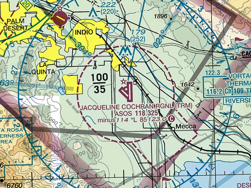
A remote pilot plans to fly a small UA at 200 feet AGL directly over the runways at JACQUELINE COCHRAN RGNL (TRM). What airspace is that, and what does Part 107 require first?
A. Class E surface area; ATC authorization is required
B. Class G airspace; no ATC authorization is required
C. Class E airspace from 700 feet AGL; no ATC authorization is required
Show the answer and explanation
Answer: A. Class E surface area; ATC authorization is required
The dashed magenta line around JACQUELINE COCHRAN RGNL (TRM) marks a Class E surface area, controlled airspace that starts at the surface. Part 107 requires prior ATC authorization to operate within the lateral boundaries of a Class E surface area designated for an airport, just as in Class B, C, and D airspace.
Why the other choices are wrong
B. Class G airspace; no ATC authorization is required Class G is uncontrolled airspace, but the dashed magenta line shows that controlled Class E airspace starts at the surface here.
C. Class E airspace from 700 feet AGL; no ATC authorization is required A 700-foot floor is shown by a magenta vignette (shaded band), not by a dashed magenta line. The dashed line marks a surface area.
No person may operate a small unmanned aircraft in Class B, Class C, or Class D airspace or within the lateral boundaries of the surface area of Class E airspace designated for an airport unless that person has prior authorization from Air Traffic Control (ATC).
Question 3
Sectional: Los Angeles, dated 29 OCT 2026 to 24 DEC 2026 FAA chart excerpt (public domain). Not for navigation.
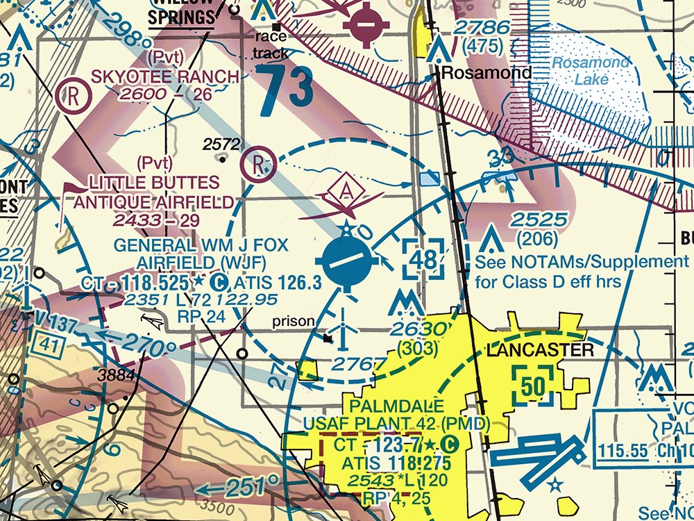
What are the vertical limits of the Class D airspace at GENERAL WM J FOX AIRFIELD (WJF)?
A. From the surface to 4,800 feet AGL
B. From the surface to 4,800 feet MSL
C. From 700 feet AGL to 4,800 feet AGL
Show the answer and explanation
Answer: B. From the surface to 4,800 feet MSL
The blue dashed line around GENERAL WM J FOX AIRFIELD (WJF) marks Class D airspace, which begins at the surface. The number in the dashed box is the ceiling in hundreds of feet MSL, and it has no minus sign, so the Class D airspace extends from the surface up to and including 4,800 feet MSL.
Why the other choices are wrong
A. From the surface to 4,800 feet AGL Class D ceilings are charted in MSL, not AGL, so the boxed 48 means 4,800 feet MSL.
C. From 700 feet AGL to 4,800 feet AGL A 700-foot AGL floor belongs to Class E airspace shown by a magenta vignette. Class D begins at the surface and its ceiling is in MSL.
Generally, Class D airspace extends upward from the surface to 2,500 feet above the airport elevation (charted in MSL)
Question 4
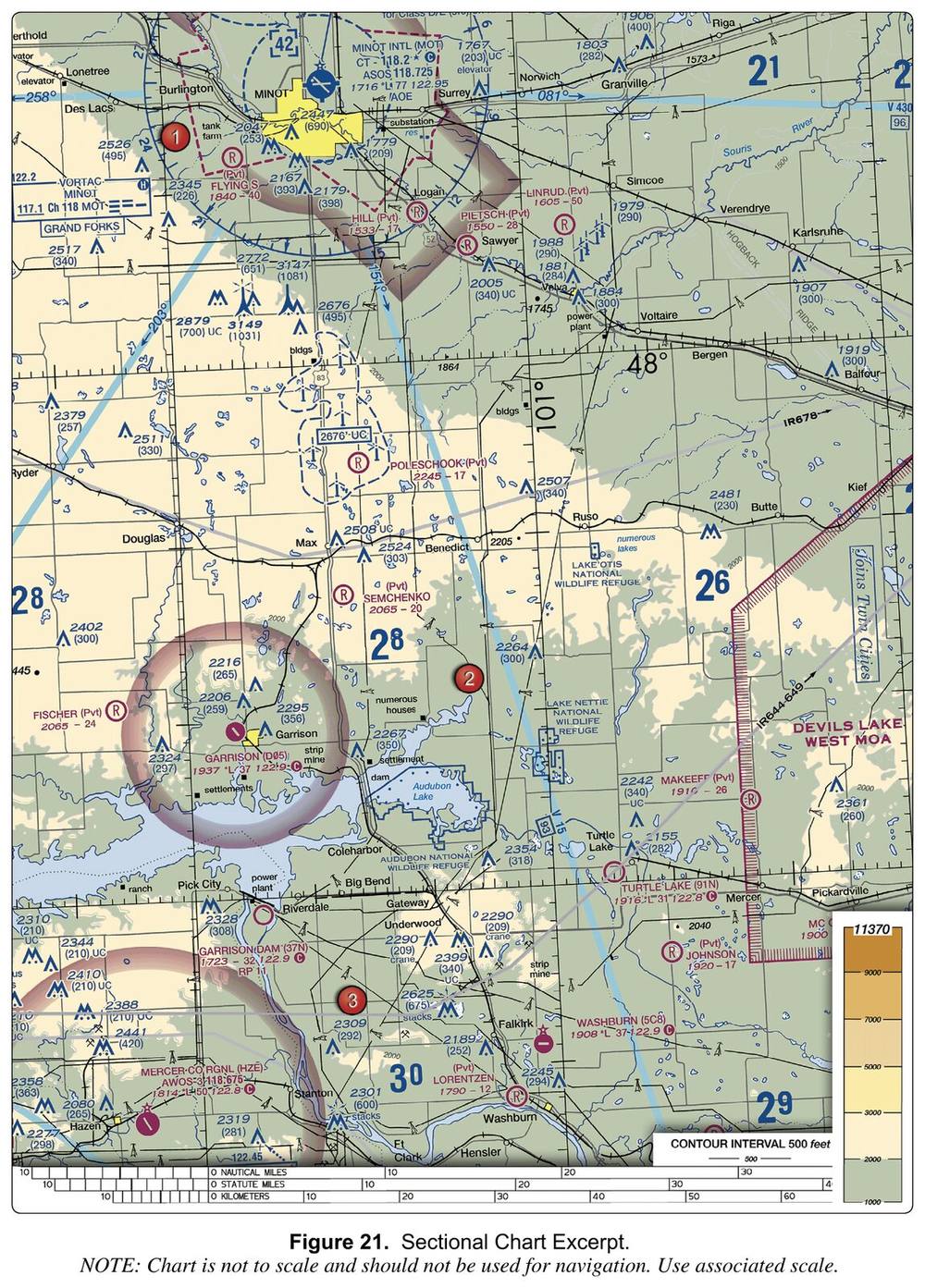
FAA-CT-8080-2H, Figure 21. Sectional Chart Excerpt. FAA Airman Knowledge Testing Supplement (public domain). 2018 excerpt, not for navigation.
Refer to Figure 21. A blue dashed line surrounds MINOT INTL (MOT), and the figure 42 appears in a dashed box. What are the vertical limits of this Class D airspace?
A. Surface to 4,200 feet AGL
B. Surface to 2,500 feet AGL
C. Surface to 4,200 feet MSL
Show the answer and explanation
Answer: C. Surface to 4,200 feet MSL
The boxed 42 is the Class D ceiling with the last two zeros left off: 4,200 feet MSL. Class D is charted in MSL; with the airport at 1,716 feet, this is roughly 2,500 feet above the airport.
Why the other choices are wrong
A. Surface to 4,200 feet AGL Class D altitudes on the chart are MSL values, not heights above the ground.
B. Surface to 2,500 feet AGL Class D is generally about 2,500 feet above the airport, but the chart gives the actual ceiling: 42, or 4,200 feet MSL.
Generally, Class D airspace extends upward from the surface to 2,500 feet above the airport elevation (charted in MSL)
Question 5
A remote PIC is sorting the special use airspace along a planned survey route. Which areas are regulatory special use airspace?
A. Military operations areas and alert areas
B. Prohibited areas and restricted areas
C. Warning areas and national security areas
Show the answer and explanation
Answer: B. Prohibited areas and restricted areas
Prohibited and restricted areas are regulatory special use airspace, established in 14 CFR part 73 through rulemaking. Warning areas, MOAs, alert areas, controlled firing areas, and national security areas are nonregulatory. Part 107 requires permission from the using or controlling agency before a small UA operates in a prohibited or restricted area.
Why the other choices are wrong
A. Military operations areas and alert areas MOAs and alert areas are nonregulatory special use airspace.
C. Warning areas and national security areas Warning areas and national security areas are nonregulatory special use airspace.
No person may operate a small unmanned aircraft in prohibited or restricted areas unless that person has permission from the using or controlling agency, as appropriate.
Question 6
Sectional: Los Angeles, dated 29 OCT 2026 to 24 DEC 2026 FAA chart excerpt (public domain). Not for navigation.
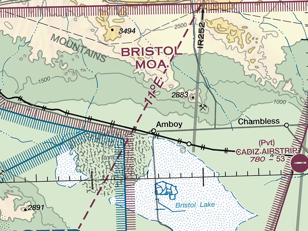
What type of special use airspace contains the point marked 1?
A. Restricted area
B. Warning area
C. Military operations area (MOA)
Show the answer and explanation
Answer: C. Military operations area (MOA)
Special use airspace is labeled by type and number or name inside or next to the area. Point 1 lies in BRISTOL MOA, so it is a military operations area (MOA).
Why the other choices are wrong
A. Restricted area Restricted areas are drawn with blue hatched borders and labeled with an R- number. The label at point 1 is BRISTOL MOA.
B. Warning area Warning areas are drawn with blue hatched borders over water and labeled with a W- number. The label at point 1 is BRISTOL MOA.
SUA areas are shown in their entirety (within the limits of the chart), even when they overlap, adjoin, or when an area is designated within another area. The areas are identified by type and identifying name/number, and are positioned either within or immediately adjacent to the area.
MOAs consist of airspace of defined vertical and lateral limits established for the purpose of separating certain military training activities from IFR traffic.
Question 7
A remote PIC learns that skydivers often jump near a planned job site. According to the AIM, where are U.S. parachute jump areas tabulated?
A. In 14 CFR part 105
B. In the Chart Supplement
C. In FAA Order JO 7400.10
Show the answer and explanation
Answer: B. In the Chart Supplement
The AIM says tabulations of U.S. parachute jump areas are in the Chart Supplement, while 14 CFR part 105 holds the procedures for them. Sites used frequently are also shown on sectional charts.
Why the other choices are wrong
A. In 14 CFR part 105 Part 105 contains the procedures for parachute jump areas; the tabulation of the areas is in the Chart Supplement.
C. In FAA Order JO 7400.10 FAA Order JO 7400.10 contains special use airspace descriptions, not parachute jump areas.
Procedures relating to parachute jump areas are contained in 14 CFR part 105. Tabulations of parachute jump areas in the U.S. are contained in the Chart Supplement.
Parachute jump aircraft operations are published in the Chart Supplement U.S. (formerly Airport/Facility Directory). Sites that are used frequently are depicted on sectional charts.
Special use airspace descriptions (except CFAs) are contained in FAA Order JO 7400.10, Special Use Airspace.
Question 8
What is the primary purpose of the air traffic control (ATC) system?
A. To brief pilots on weather and process their flight plans
B. To prevent collisions and organize and expedite traffic flow
C. To provide additional services whenever a pilot asks for them
Show the answer and explanation
Answer: B. To prevent collisions and organize and expedite traffic flow
The primary purpose of the ATC system is to prevent collisions between aircraft operating in the system and to organize and expedite the flow of traffic. ATC can also provide additional services, but only as far as factors such as traffic volume, frequency congestion, and controller workload allow.
Why the other choices are wrong
A. To brief pilots on weather and process their flight plans The study guide does not name weather briefings or flight plans as the primary purpose of the ATC system; that purpose is preventing collisions and organizing and expediting traffic flow.
C. To provide additional services whenever a pilot asks for them Additional services come second to the primary function and are limited by traffic volume, frequency congestion, controller workload, and other factors.
The primary purpose of the ATC system is to prevent a collision between aircraft operating in the system and to organize and expedite the flow of traffic.
The ability to provide additional services is limited by many factors, such as the volume of traffic, frequency congestion, quality of radar, controller workload, higher priority duties
Question 9
On a hazy afternoon, the remote PIC cannot identify prominent unlighted objects more than 2 statute miles from the control station. Which action allows the small UA to be flown under Part 107 without a waiver?
A. Keeping the UA within 2 statute miles of the control station
B. Turning on the UA's anti-collision lights for the flight
C. Waiting until flight visibility is at least 3 statute miles
Show the answer and explanation
Answer: C. Waiting until flight visibility is at least 3 statute miles
Without a waiver, Part 107 requires a minimum flight visibility of 3 statute miles, as observed from the control station. By day, flight visibility is the average slant distance at which prominent unlighted objects can be seen and identified, so haze that limits it to 2 statute miles keeps the small UA on the ground until visibility improves. A certificate of waiver may authorize a deviation from § 107.51 (§ 107.205(i)).
Why the other choices are wrong
A. Keeping the UA within 2 statute miles of the control station The 3-statute-mile minimum is observed from the control station and does not depend on how far the UA flies, so staying close does not make up for low visibility.
B. Turning on the UA's anti-collision lights for the flight Lights do not change the visibility minimum; § 107.51(c) still requires flight visibility of at least 3 statute miles from the control station.
Section 107.51—Operating limitations for small unmanned aircraft.
Question 10
A remote PIC plans a Part 107 survey at noon, well outside civil twilight. What does Part 107 require for the small UA's anti-collision lighting?
A. None, though the remote PIC may choose to turn lighting on
B. Lit anti-collision lighting visible for at least 3 statute miles
C. Anti-collision lighting only when flying near an airport
Show the answer and explanation
Answer: A. None, though the remote PIC may choose to turn lighting on
Part 107 requires lit anti-collision lighting visible for at least 3 statute miles for operations at night and during civil twilight. AC 107-2A notes that the rule does not require it during the day, because lighting is generally not effective for reducing collision risk in daytime, but remote pilots may choose to use it.
Why the other choices are wrong
B. Lit anti-collision lighting visible for at least 3 statute miles The 3-statute-mile lighting rule applies at night and during civil twilight, not to a noon flight.
C. Anti-collision lighting only when flying near an airport Part 107 ties anti-collision lighting to night and civil twilight, not to flying near an airport.
The small unmanned aircraft has lighted anti-collision lighting visible for at least 3 statute miles that has a flash rate sufficient to avoid a collision.
No person may operate a small unmanned aircraft system during periods of civil twilight unless the small unmanned aircraft has lighted anti-collision lighting visible for at least 3 statute miles
Question 11
LAANC isn't available for a planned job in Class C airspace. According to the AIM, through which other FAA process can a Part 107 remote PIC request the airspace authorization?
A. The FAA DroneZone
B. The B4UFLY app
C. The TFR website
Show the answer and explanation
Answer: A. The FAA DroneZone
The AIM says Part 107 operators can request airspace authorizations via LAANC or DroneZone to fly in Class B, C, or D airspace or a Class E surface area for an airport. DroneZone is the FAA's portal for registering drones and requesting Part 107 airspace authorizations and waivers.
Why the other choices are wrong
B. The B4UFLY app B4UFLY helps recreational flyers with situational awareness. It isn't a Part 107 authorization process.
C. The TFR website The TFR website shows temporary flight restrictions. It doesn't issue airspace authorizations.
Part 107 sUAS operators can request airspace authorizations via Low Altitude Authorization and Notification Capability (LAANC) or DroneZone to fly within Class B, Class C, Class D or within the lateral boundaries of the surface area of Class E airspace designated for an airport.
A remote PIC plans regular jobs near a busy airport. According to the AIM, where do a high percentage of near midair collisions occur?
A. Above 10,000 feet MSL, along major airline routes
B. Over open country, more than 50 miles from airports
C. Below 8,000 feet AGL, within 30 miles of an airport
Show the answer and explanation
Answer: C. Below 8,000 feet AGL, within 30 miles of an airport
The AIM warns that a high percentage of near midair collisions occur below 8,000 feet AGL and within 30 miles of an airport, and it recommends extra vigilance in these congested areas. A small UA working near an airport is inside exactly that zone, so the crew's traffic scan matters most there.
Why the other choices are wrong
A. Above 10,000 feet MSL, along major airline routes The AIM places a high percentage of near midair collisions low and close to airports, not at high altitude.
B. Over open country, more than 50 miles from airports The AIM links near midair collisions to congested areas within 30 miles of an airport, not remote country.
A high percentage of near midair collisions occur below 8,000 feet AGL and within 30 miles of an airport.
Question 13
A remote PIC plans a night flight near a theme park that sometimes holds outdoor laser light shows. Where does the AIM say to look for information on these laser activities?
A. The sectional chart legend only
B. The theme park's public website
C. NOTAMs or the Chart Supplement
Show the answer and explanation
Answer: C. NOTAMs or the Chart Supplement
Outdoor laser light shows can cause temporary vision impairment miles from the site, so pilots should know where they are held and avoid those areas if possible. When the FAA learns of these activities, it issues NOTAMs, and pilots should consult NOTAMs or the Chart Supplement for information.
Why the other choices are wrong
A. The sectional chart legend only The AIM points pilots to NOTAMs or the Chart Supplement for laser activity, not just the chart legend.
B. The theme park's public website The AIM directs pilots to FAA sources: the NOTAMs issued for the events, or the Chart Supplement.
Pilots should make themselves aware of where these activities are being conducted and avoid these areas if possible.
Question 14
According to the AIM, when does a Flight Service briefing include NOTAMs on open-duration special security instructions?
A. They are briefed only when the pilot requests them
B. They are included automatically, with no request needed
C. They are briefed only after the pilot files a flight plan
Show the answer and explanation
Answer: A. They are briefed only when the pilot requests them
Airway NOTAMs, procedural NOTAMs, and NOTAMs that are general in nature and not tied to a specific airport or facility, such as flight advisories and restrictions, open-duration special security instructions, and special flight rules areas, are briefed solely by pilot request. Briefers review these NOTAMs upon request, so a pilot who has not already reviewed them should ask for them.
Why the other choices are wrong
B. They are included automatically, with no request needed These general NOTAMs are not part of what the briefer provides automatically; the AIM says they are briefed solely by pilot request, so the remote PIC must ask for them.
C. They are briefed only after the pilot files a flight plan The AIM ties these NOTAMs to a pilot request, not to filing a flight plan: they are briefed solely by pilot request.
NOTAMs that are general in nature and not tied to a specific airport/facility (for example, flight advisories and restrictions, open duration special security instructions, and special flight rules areas) are briefed solely by pilot request.
Airway NOTAMs, procedural NOTAMs, and NOTAMs that are general in nature and not tied to a specific airport/facility (for example, flight advisories and restrictions, open duration special security instructions, and special flight rules areas) are briefed solely by pilot request.
A review of airway NOTAMs, procedural NOTAMs, and NOTAMs that are general in nature and not tied to a specific airport/facility (for example, flight advisories and restrictions, open duration special security instructions, and special flight rules areas)
Question 15
A remote PIC is packing equipment for a night operation. Based on FAA night-flight planning guidance, which flashlights should be brought along?
A. A single bright light for both the preflight and the flight
B. One red-lens light only, since white light ruins night vision
C. At least two: one for preflight and a smaller dimmable one
Show the answer and explanation
Answer: C. At least two: one for preflight and a smaller dimmable one
For a night flight, the PHAK advises a preflight check of all aircraft lights, interior and exterior, and carrying at least two flashlights: one for the exterior preflight and a smaller one that can be dimmed and kept nearby.
Why the other choices are wrong
A. A single bright light for both the preflight and the flight One light does not match the guidance, which calls for at least two, including a smaller one that can be dimmed.
B. One red-lens light only, since white light ruins night vision The guidance calls for at least two flashlights, one of them a smaller light that can be dimmed, not a single red light.
A remote PIC sees white strobe lights on two tall structures flashing in a middle, top, then bottom sequence. What do these lights indicate?
A. They support overhead wires strung between them
B. The structures are wind turbines in a wind farm
C. Each is a single tall obstruction, such as a chimney
Show the answer and explanation
Answer: A. They support overhead wires strung between them
Some supporting structures of overhead transmission lines carry white strobes that flash in a middle, top, bottom sequence to show that wires span the area between them. Single tall structures such as chimneys use white lights whose levels flash simultaneously, and wind turbines are typically lit with flashing red lights.
Why the other choices are wrong
B. The structures are wind turbines in a wind farm Wind turbines are typically lit with medium-intensity flashing red lights on the nacelle, not sequenced white strobes.
C. Each is a single tall obstruction, such as a chimney When a single tall structure has several levels of white lights, the levels flash simultaneously rather than in a middle, top, bottom sequence.
In some locations, the supporting structures of overhead transmission lines are equipped with unique sequence flashing white strobe light systems to indicate that there are wires between the structures.
They are typically lit with medium-intensity, flashing red lights, placed as high as possible on the turbine nacelle (not the blade tips)
Question 17
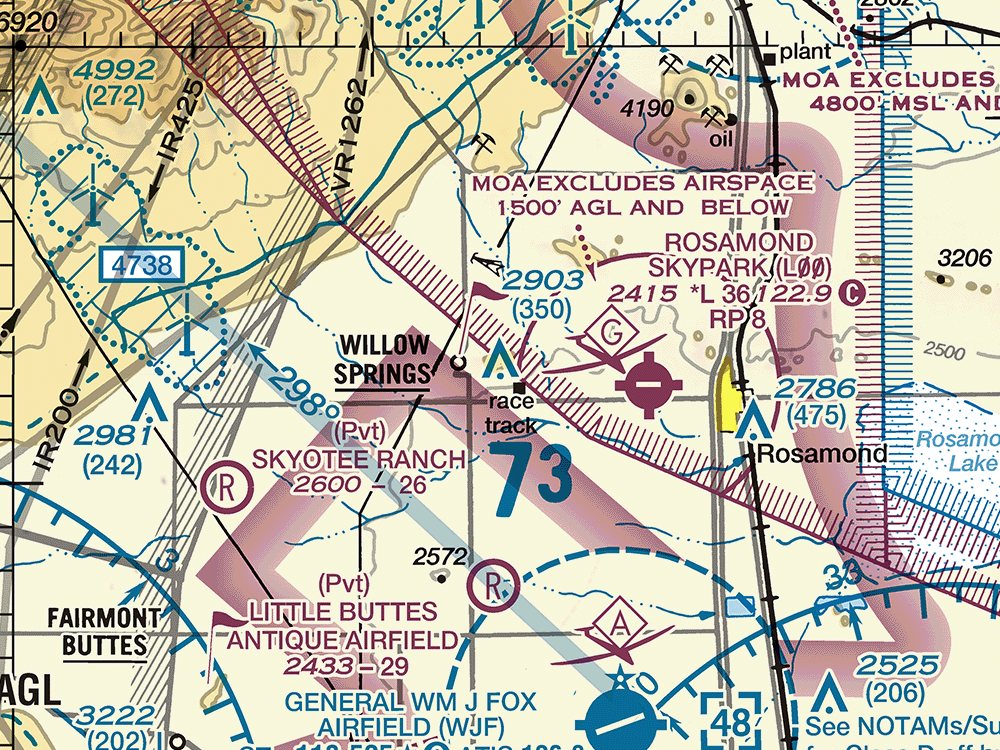
Sectional: Los Angeles, dated 29 OCT 2026 to 24 DEC 2026 FAA chart excerpt (public domain). Not for navigation.
What is the height of the obstacle marked 1 above ground level (AGL)?
A. 350 feet
B. 2,553 feet
C. 2,903 feet
Show the answer and explanation
Answer: A. 350 feet
Sectional charts print an obstacle's top elevation in MSL with its height above ground level in parentheses below it. The obstacle marked 1 shows 2903 over (350), so it is 350 feet tall (AGL) and its top is at 2,903 feet MSL.
Why the other choices are wrong
B. 2,553 feet 2,553 feet is 2903 minus 350, the approximate ground elevation at the base, not the obstacle's height.
C. 2,903 feet 2,903 feet is the elevation of the top above mean sea level (MSL), not the height above the ground.
The AGL height is in parentheses below the MSL elevation.
Question 18
A remote PIC plans a survey at 150 feet AGL over rural farmland. According to the AIM, why must the crew watch closely for power lines and towers at this height?
A. They are charted, so the main risk is misreading the chart symbols
B. Many at or below 200 feet AGL are not marked, lit, or charted
C. Lights mark them, though sun glare can hide the lights by day
Show the answer and explanation
Answer: B. Many at or below 200 feet AGL are not marked, lit, or charted
The AIM cautions that at and below 200 feet AGL there are numerous power lines and antenna towers that are not marked and lighted or charted as obstructions, so they may not be seen in time to avoid a collision. New obstructions may also be missing from current charts.
Why the other choices are wrong
A. They are charted, so the main risk is misreading the chart symbols Many low obstructions are not charted at all, and new ones may be missing from current charts.
C. Lights mark them, though sun glare can hide the lights by day The AIM says numerous power lines and towers at and below 200 feet AGL are not marked and lighted, so lights cannot be counted on to reveal them.
At and below 200 feet AGL there are numerous power lines, antenna towers, etc., that are not marked and lighted and/or charted as obstructions and, therefore, may not be seen in time to avoid a collision.
Additionally, new obstructions may not be on current charts because the information was not received prior to the FAA publishing the chart.
Question 19
A remote PIC operating near an airport in daylight watches for manned aircraft lights. Which statement about manned aircraft lighting is correct?
A. Anti-collision lights are red beacons, not white strobes
B. Landing lights are required on all flights below 10,000 feet
C. Some aircraft have no lights, and some fly with them turned off
Show the answer and explanation
Answer: C. Some aircraft have no lights, and some fly with them turned off
The AIM cautions that not all aircraft are equipped with lights and some pilots may not turn their lights on, so a remote PIC cannot count on lights to spot traffic and should keep a sharp lookout. Landing light use under Operation Lights On is voluntary, and anti-collision systems may use rotating beacons or strobes in red or white.
Why the other choices are wrong
A. Anti-collision lights are red beacons, not white strobes An anti-collision light system can use rotating beacons and/or strobe lights, colored either red or white.
B. Landing lights are required on all flights below 10,000 feet Landing light use below 10,000 feet is encouraged under the voluntary Operation Lights On program, not required.
Although turning on aircraft lights does enhance the see-and-avoid concept, pilots should not become complacent about keeping a sharp lookout for other aircraft.
Pilots are further encouraged to turn on their landing lights when operating below 10,000 feet, day or night
These questions are original and written from public FAA documents. Chartpass is not
affiliated with, endorsed by, or sponsored by the FAA. Chart excerpts are FAA public domain material and
are not for navigation.
 Chartpass